After Roman withdrawal from Britain in 410 AD, various petty invasions and squabbles between local warlords took place, and by the 7th century Anglian immigrants had moved into the region and occupied the land.
Most of the place names of Tameside reflect this influence. The River Tame itself (probably Norse meaning "dark river"), and other places such as Werneth Low ("a place growing alder trees") as well as Ashton and Denton (the Scandinavian word "ton" indicates a town or settlement) - all show clear Anglian-Continental sources.
Oddly, there seems to be little evidence of native British place naming within the borough, suggesting that the Anglian invaders were its first inhabitants and it had been hitherto unoccupied woodlands.
http://www.manchester2002-uk.com/towns/tameside1.html
=======================
http://www.ashton-under-lyne.com/mossley.htm
The small Pennine town of Mossley lies just over the hill from Ashton under Lyne. The character of the town is very different, with its steep streets and stone houses.
Before it became a borough in 1885, Mossley was divided between three counties. Brookbottom (Top Mossley) and Bottoms (Bottom Mossley) were in Lancashire. This part of the town was historically part of the old parish of Ashton. Quickedge, Milton and Roughtown were in the West Riding of Yorkshire. The part to the east of the River Tame, including Micklehurst, was in Cheshire. The borough became part of Lancashire until 1974, when it became part of the Metropolitan Borough of Tameside.
High on the eastern sky-line of Mossley is Buckton Castle, an iron age hill fort. The remains of the defensive ridge and ditch are still to be seen. Below it, and forming a boundary between the steep moorland and the enclosed fields, an ancient road way runs around the hillside. The Romans made use of this road and paved part of it, using it as a route between the camps of Melandra (Glossop) and Castleshaw (Saddleworth).
The area was at one time densely forested but over many years, the trees were mostly felled and the hillsides used to graze sheep. Wool production became the chief industry, with many weaver's cottages being built, incorporating a weaving room. When powered looms were invented, woollen mills and later, cotton mills were constructed in the valley.
The earliest settlements in the area, such as Brookbottom and Roughtown, were high above the valley of the River Tame. With the building of the canal and later the railway, along with the mills being constructed along the valley bottom, Mossley spread out to fill the valley.

Buckton Castle is a medieval ringwork/a good example of a Norman motte and bailey castle and is likely to have been constructed in the 12th century on the site of a prehistoric hillfort.
http://carrbrookvillage.users.btopenworld.com/buckton.htm
| Greater Manchester Archaeology Unit, based at Manchester University, is due to do a dig at Buckton Castle in 2003- 2004. A pocket book history of Buckton Castle is due to be published in 2004-2005. |
| |
| |
| |
Redeposited ditch material was identified overlying charcoal and peat layers which were carbon dated to AD 765-1010;AD 700-1000 & AD 570-765. It appears that this site is also assumed to be an Iron Age hill fort.
http://homepage.mac.com/philipdavis/English%20sites/2929.html
=================
http://www.megalithic.co.uk/article.php?sid=4774
Other sites nearby: ( * = Image)
OLD: Pop-up a map of these sites
NEW: View this page with an embedded Yahoo Map
NEW: Download or link to a GeoRSS feed of these sites
1.8km S Harridge Pike Cairn (SJ994999)
3.7km S Stalybridge Cairn* Cairn (SJ989980)
3.7km S Hobson Moor Cairn I Cairn (SJ990980)
4.5km S Buckton Edge Cairn (SJ989972)
4.5km S Hobson Moor Cairn II Cairn (SJ991972)
5.8km N Delph Tumulus Round Barrow(s) (SD980074)
7.3km SE Mouselow Castle Hillfort (SK027954)
7.5km N Jackson's Barrow* Round Barrow(s) (SE00200905)
7.9km E Highstones earthwork* Misc. Earthwork (SK064990)
7.9km E Holgate Howe Cup & Ringmarks Cup and Ring marks / Rock Art (SE064044)
8.4km E Holgate Howe Barrow Round Barrow(s) (SE067048)
8.5km S Hangingbank, Werneth Low* Ancient Village or Settlement (SJ965935)
8.6km S Lower Higham Farm Cairn (SJ961935)
8.7km S Werneth Low Enclosure Ancient Village or Settlement (SJ970932)
8.8km S Hargate Hill* Standing Stone (Menhir) (SK01239315)
9.0km S Werneth Low Cairn Cairn (SJ969929)
9.1km E Black Hill Cairn (SE074051)
10.4km S Ludworth Intake* Round Barrow(s) (SJ990913)
10.8km S Brown Low* Round Barrow(s) (SJ988909)
10.9km S Robin Hood's Picking Rods* Ancient Cross (SK006909)
===========
Legend has always told that great treasure existed beneath the grounds of this Brigantian hillfort, found on the moor-edges to the east of Manchester. Long ago, one man came along to see if he could find the treasure, said to consist of a huge chest of gold. The man brought two horses and the ground within the fort was gradually cleared away until, to the man's surprise, the legendary chest was revealed!
Attaching chains to it and the horses, the man shouted:
"Gee, whoa, whoo! Bonny, Buck and Bell,
I'll have this chest o' gowd, i' spite o' all t'devils in hell!"
But barely had the words left his mouth and the chest began to move, when the devil himself appeared in the shape of a huge hen that breathed fire! This scared the horses so much that they bolted and snapped the chains, taking their master with them but leaving the treasure-chest still in the ground. To this day the chest still remains, hidden in the Earth.
Source:
Winterbottom, Vera, The Devil in Lancashire, Cloister: Stockport 1962.
http://www.themodernantiquarian.com/site/8663
============

Hartshead pike serves as a focal point in the Oldham landscape, visible from miles around with unbroken views across 4 counties. This has been a beacon hill through antiquity.
Before the Romans the local tribes lit fires here to celebrate the cycle of the seasons, there were many ancient sites close by, including a stone circle at Buckton Castle, once visible from the pike it is now sadly lost. It is highly probable that the druids worshiped at Hartshead Pike during the Iron Age, and sacrifices may have been held to appease their gods.
During the Roman occupation the area took on a more mundane role and became a beacon site, the trackways became routes for the Romans to navigate quickly between the fort at Buckton, and the Roman road at Limeside. The beacon may have been lit in times of unrest to warn the local garrisons.
After the departure of the Romans much of Oldham was inhabited by the Anglo Saxons. There has been some suggestion that the pike was the site where they held their mote (moot) - to appoint leaders and to create law, and the name Hartshead may come from their habit of marking a meeting place with the skull of a wild animal (although this is pure speculation).
In more recent times the pike has been the scene for UFO sightings collected by researchers in the area, although some of the distant sightings may have been misidentified aeroplanes landing at Manchester Airport.
http://www.mysteriousbritain.co.uk/england/greatermanchester/grtman1.html
============
Since 1990, the University of Manchester has been involved in a long-term survey and research project of Tameside, funded by the council, with the aim of assessing existing archaeological evidence and using it to identify new areas of likely archaeological interest.
http://www.tameside.gov.uk/corpgen/millennium/yearbook10.html
The first three volumes cover the Prehistoric, Roman and Dark Age periods prior to 1066, the medieval and early post-medieval communities of Tameside between the centuries from 1066-1700, and the industrial period covering the years 1700 to 1930. Those have been followed by a volume dealing with the formative historical personalities of the area and another dealing with the borough's historic buildings and structures.
===========
Sites and Buildings of Interest
http://www.tameside.gov.uk/corpgen/millennium/yearbook11.html
=============
"Scout Tunnel in Mossley is the only tunnel in Tameside and is 200 yards long. If you were to stand at the top of Scout Tunnel looking towards the railway line in the direction of Woodhead Tunnel, there you will see on the hillside a horse which is cut out of heather."
http://www.mossleyonline.co.uk/local_info/info_know.html
==================
The Blue Plaque at Gorse Hall Estate, Stalybridge, celebrates the site of Gorse Hall which was built by Beatrix Potter's maternal grandparents, John and Jane Leech. Beatrix often visited Gorse Hall with her mother, Helen Leech.
Beatrix Potter Gorse Hall Estate, Stalybridge
========
Welcome to the official web site of The Mossley Band - the Championship Section brass band with an incredible history spanning over 150 years.
http://www.mossleyband.co.uk/

| |
| The Mossley Band 1961 |
The Brewery -The Millstone Brewery restores a traditional craft to the town of Mossley, situated where the counties of Cheshire, Lancashire and Yorkshire meet. Vale Mill, originally part of Mossley’s cotton heritage, provides an appropriate home for the eight-barrel plant that was installed in September 2003. Brewing commenced in early October.
http://www.millstonebrewery.co.uk/
================
Long Live the Fish and Chip Shop
Along with the history of fish and chips comes the colourful history of the fish and chip shop.
The first fish and chip shop in the North of England is thought to hove opened in Mossley near Oldham, Lancashire, around 1863. Mr Lees sold fish and chips from a wooden hut in the market and later he transferred the business to a permanent shop across the road which had the following inscription in the window "This is the first fish and chip shop in the world."
But in London, Joseph Malin opened a fish end chip shop in Cleveland Street within the sound of Bow Bells 13 in 1860
http://www.niagara.co.uk/fish_and_chips.htm
=====================
About the Roaches Lock * Music Venue
The Roaches Lock Inn stands in a picturesque setting between the Huddersfield narrow canal and the river Tame in Mossley, near Ashton, Manchester UK
Live music - every Friday and Saturday
Large beer garden on the canal side * Non smoking dining area
Real ales - and decent wine...
Gig requests,
Please send Band details and sample CD to the following address.
Roaches Lock Inn,
387 Manchester Road, Mossley,
Lancashire,
OL5 9BB
Tel. number 01457 834288
================
Ashton Market Hall Webcams
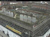
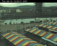
View a larger image of webcam1 View a larger image of webcam2
These webcam views show regularly updated images every 5 minutes of work in progress within Ashton Market Hall.
As you can see, work has commenced on the restoration of our historic Market Hall which was gutted by fire in May 2004. Contractors employed by Tameside MBC have started the enabling works to allow the main contract to follow on and the work is expected to be completed by late Spring 2008.
No comments:
Post a Comment